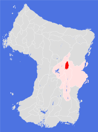
Illhe
Societal ties: Balhe
Current population: 1
Main language(s): Gevey
Area: 73,000km²
Natural and political borders
The Land nestles between the Zoiznuu Illhizhuu and Zoiznuu Kavadhizhuu ranges, at the northernmost tip of the Taetuu valley. It has nominal control of the Taetuu river north of latitude 20.0°N - though this is disputed by the Land of Taete, which refuses to recognise the Land's right to exist.
History
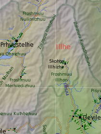
History didn't come to the Froshmuu Illhon until fairly recently. The Seer Mi'huede and his followers arrived in the high valley in gt1026, after being denied entry to the city of Gevile and threatened with slaughter if the fundamentalists did not leave the Taete valley. Instead of going west, Mi'huede led his followers northwards, beyond the volcano, where they began gathering together enough soil from the valley and the volcano, and preparing it for cultivation.
Since the arrival of the Seer, nothing much has happened. The settlement has little contact with the outside world - attempts to make contact with the settlers are routinely rebuffed, often at the point of an antique gun. The Land of Taete also lays claim to this area, but has done nothing (to date) to enforce this claim, and the authorities seem happy to let the settlement get on with its own affairs as long as it causes no trouble further south. The Taete civil guard maintains a guard post on the river at latitude 21.1°N, which has come to be seen as the de-facto border between the two Lands.
Politics and economy
Little is known about the politics and economics of the Land. It is assumed that the economy is a subsistence one, as recent aerial photos do not show any signs of industrial activity beyond cultivating the soil. The Seer Mi'huede preached a strict form of fundamentalist belief in the vengeful god, so it is assumed that his descendants still follow a form of theocratic governance.
Culture and other issues of interest
Nothing to report.
Key natural features
Illhe is a mountainous Land - its lowest point is 850m above current sea level. Set in the angle where the western and eastern mountain ranges of the Taete valley meet, it is considered to be more vertical than horizontal. Key mountains surrounding the Froshmuu Illhon include Mts. Illhjarhon (4,390m), Kavadhon (5,400m) and Zhawhaenuu (4,430m). Mount Illhon itself, a volcano set in the lower part of the high valley from which it takes its name, only rises to 2,450m.
Habitats
Illhe can be divided into three ecological regions: the northern part of the Land is the domain of the north central mountains habitat; further south is found a central lakelands habitat (though this habitat differs from the main habitat of that name in some small, but significant ways); finally a high valleys habitat dominates in the southern central valley.
Plantations and settlements
Only the one settlement has been established in the high valley, north of Illhon volcano which provided much of the soil used for the cultivation.
Key towns and cities
Rural population: 0 (0.0% of total)