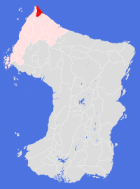
Elimnarhe
Societal ties: Bartak
Current population: 1
Main language(s): Varam Bathtel
Area: 46,000km²
Natural and political borders
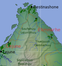
Occupying the eastern part of the northernmost tip of the continent, Elimnarhe stretches some 480km south from the Destinashone cape to the Souvjarhuu Paasizhuu, with the Soufwhuu Lejunizhuu forming the western border of the Land.
The coastal border between Elimnarhe and Koletane (to the south) was set at latitude 50.7°N as part of the New Bartekol Agreement in 751. The coastal border with Lejune sits at longitude 158.8°E.
History
Elimnarhe is considered to be, even by its natives, a bit of a backwater. Survival has always been the main consideration of the population. During the Disaster and evacuation, few refugees arrived directly at Destinashone; most of the population arrived via Lejune or Dashelone.
Since the Disaster, little has happened. The plantation expanded slowly, and new settlements were established when population pressures in Destinashone required them. One key achievement was the development of apple orchards in older cultivated fields in the gt560s. When the Bartekol League formed in gt720, Destinashone became a founding member, and the Land of Elimnarhe came into existence as part of the New Settlement in gt751. Between these dates, the city was happy to sell its votes in the League to whichever group would pay the most.
There was a movement in during the gt860s for the Land to join with Koletane - though much of the support in the temples was funded by Koletane businesses. The proposal went to a plebiscite vote in gt868, and lost heavily.
The Land's population passed the 100,000 mark in gt910, and has continued to grow slowly since then. The more recent technological advances have made life in the city and settlements much easier, but have had no other particular impact on the politics or culture of the Land.
Politics and economy
Elimnarhe is a major producer and exporter of apples and other soft fruit, which are considered to be the best grown on the entire continent. They export less in the way of cider or pork (the other speciality agricultural produce), preferring to keep them for home consumption. Other than these cash crops, little trade occurs between this Land and its neighbours, as the cultivations meet almost all of the population's requirements.
This wasn't always the case. Prior to gt867, when the new trade route between Aelhpaase and Omne first opened, there were only two ways for the western and eastern Bartak Lands to travel and communicate with each other: either by ship (usually between the cities of Verhine/Lejune and Dashelone); or alternatively overland by way of Destinashone. In either case, travel between west and east was generally confined to the summer months with its better weather. Sea travel was swifter but more dangerous, while land travel was much slower, arduous, but safer. Much of this business petered out following the opening of the new trans-mountain routes, though the impact on the local economy was not as profound as it could have been.
In a way, Destinashone is Elimnarhe. There is no Land government as such; rather politics is conducted at the city and settlement level, with the settlements generally happy to follow the lead of the city. Security structures are limited to the city police, who also provide (intermittent) support for the settlements. Most decisions are made in the local temples, who together nominate people to serve as city and settlement councillors.
The Land does have its own currency, but the currencies of neighbouring Lands have equal standing and are widely accepted.
Culture and other issues of interest
Even though the population appears insular, they are friendly towards strangers. Population movements between city and settlement are common, and the city has a younger age profile than the settlements. Over the past 50 orbits young Elimnarheans have begun traveling further afield, taking work in other Lands and sending back money to their families and communities - a typical sojourn will last 4 or 5 orbits before homesickness brings the economic migrants back home.
Key natural features
The Land is composed mainly of mountain foothills - the Thakluush Oemnarhuu. Rivers through these hills tend to be short and swift. The longest river reaches deep into the mountains and includes some stunning mountain lakes.
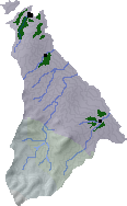
Habitats
Northern coastal habitat covers the northern half of this Land, and has proven to be the only habitat capable of being cultivated at these latitudes. Traveling southwards, northern valley and northern scrublands habitats are passed through, before reaching the northern mountains habitats surrounding Mts. Leje (4,630m) and Paasjarhe (5,070m) on the southern border.
Plantations and settlements
Elimnarhe is a sparsely populated Land - regularly battered by large temperate cyclonic systems throughout the year, thus very wet, cool and windswept. Few refugees chose to settle here, and little has changed since the Disaster to improve the desirability of the place.
Destinashone Plantation, at the northern tip of the Land, was established by pioneers from Lejune in 508, who were looking to ease the pressure of new emigrants arriving from Cheidrah. For a long time this was the only cultivated area on this part of the coast. Despite the conditions, the cultivation has proven to be productive, and particularly amenable to the growing of crops such as apples and similar temperate soft fruits. The current cultivation extends some 60km inland.
Two other settlements were established along the coast in the 580s, principally as resting stations on the trail southeast towards the city of Dashelone. However, attempts to cultivate the interior of the Land - in the 660s, 740s and more recently in the 1150s - have all failed.
Key towns and cities
Rural population: 0 (0.0% of total)