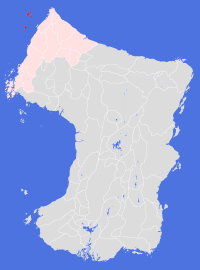
Kaarname
Societal ties: Bartak
Current population: 1
Main language(s): Kanis, Dam Bathtel
Area: 9,000km²
Natural and political borders
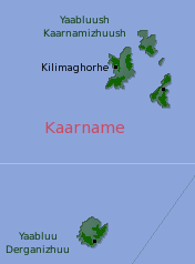
Kaarname consists of two sets of islands: the Yaabluush Kaarnamizhuush, a set of four main islands, lie some 230km northwest of Smikuu Lejun; Yaabluu Derganizhuu is 250km south of the main isles.
History
Evidence has been uncovered that sailors from various parts of Cheidrah had established seasonal camps on the islands before the signing of the Cheidran Grand Treaty. These settlements probably became more permanent sometime in the mid fourth century, and were supporting a population of over 100,000 by gt450.
The assistance of Kaarname islanders was critical to the Tells Authority's plans to colonise the continent, providing both manpower for the pioneer teams and expertise on how best to cultivate the western coastal habitats. The islands were also able to absorb the early refugees - by gt600 the population had reached more than 100,000 and almost all of the available land in the largest islands was under active cultivation. The population declined rapidly in the centuries following the collapse of the Tells Authority, then recovering to present day levels in around gt820
The island settlements chose not to join the Bartekol League when it was formed in gt720, but did join as a Land in its own right as part of the New Agreement in gt751.
The main danger to the Land's existence has been the weather. A massive winter storm in gt790 wiped out two settlements overnight, with great loss of life. Other storms over the centuries have caused crop failures and soil sourings, and damage to settlement structures. The last major storm damage occured in gt1172 when massive waves wrecked Kilimaghore harbour (now rebuilt).
Politics and economy
The economic wealth of the Land has always depended on the sea - most agricultural produce grown in the settlements is kept for local consumption. The isles have always been the first port of call for ships traveling across the ocean from Cheidrah; while the number of ships arriving each year has greatly diminished, some still do make the journey.
Politics is an entirely local affair, with each settlement looking after their own. The Land administration is effectively the leaders of the three settlements. All settlements contribute to the costs of disaster recovery, and the Land maintains a small navy to tackle piracy.
Culture and other issues of interest
Surprisingly, perhaps, the islanders are among the most secular people in Bartak Society. The role of the temple has been largely replaced by "neighbourhood gatherings", regular social occasions generally held in the evening involving music, dancing, and - before the drinking commences - local politics and dispute resolutions.
Key natural features
The isles are hilly rather than mountainous - the highest point in the isles (on Dergan Isle) is 506m above current sea levels.
Habitats
The isles have a western coastal habitat, though many of the Type One life species found there have adapted in unique ways to their island homes. Interestingly, Dergan Isle is the only area of Ewlah (apart from the higher mountains) which lacks a native population of goats.
Plantations and settlements
All bar the smallest of the main islands have been heavily cultivated over the centuries, and the land has proven to be highly productive. Today, large tracts of land remain cultivated, but untended.
Currently, the isles support three settlements, one settlement on each of the three largest islands. The main settlement - Kilimaghorhe - is not the largest, but hosts the safest harbour in the isles, and acts as the Land's administrative centre.
Key towns and cities
Rural population: 0 (0.0% of total)