Gromane
Societal ties: Ambostak
Current population: 1
Main language(s): Ramajal
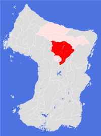
Area: 895,000km²
Natural and political borders
Apart from Rasluu Samen, the Land of Gromane is entirely surrounded by mountain ranges: Soufwhuush Rindizuush; Zeesuu Sumuu; Soufwhuum Frhitizhuum; Zoiznuu Kandan; Zoiznajarhuu Pesan; Zoiznuu Estolizhuu; Zeesuu Aframuu; Zoiznuu Gana'huu; Zeesuu Baarhduu; and Soufwhuush Riplizhuush.
The northern border is set at latitude 34.8°N, where the Rasluu Samen rapids are at their steepest. In the south west a second political border sits at latitude 27.7°N between Zeesuu Aframuu and Zoiznuu Estolizhuu.
History
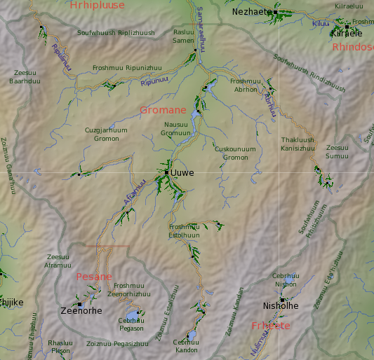
The first expedition to pass south of the Rasluu Samen was Behrl Groman's of gt677-78. Not until Uuwe Ripun returned from mapping the valleys of the Gromane Plateau in gt737 did anyone even consider that the Gromane plateau (as Ripun had named it) was in any way habitable. Further scientific explorations followed over the next two centuries.
The first permanent settlement, above the Samarhaelhuu river rapids, was established by temple pioneers in gt784 as a spiritual retreat. A second settlement in the Froshmuu Abrhon was established by Rhindose prospectors in gt860; the area yielded good quantities of base metals, encouraging further expeditions. The breakthrough came in gt889 when rich seams of coal were found near the surface in the upper reaches of Nausuu Gromon - suggesting that at some point in its history the plateau had been submerged by shallow seas. The discovery led to the rapid establishment of Uuwe Plantation; other settlements in the south and west were soon exploiting similar coal beds.
By the start of the twelfth century there were 10 permanent settlements in the high desert valleys, including Uuwe Plantation, with a permanent population of around 40,000 augmented by a similar number of short-term contract workers. In gt1100 the permanent settlers decided to form their own Land and started negotiations with other Ambostak Lands to realise this desire. The Treaty of Uuwe, signed in gt1102, established the independent Land of Gromane covering all the area south of the Rasluu Samen while at the same time allowing other Lands some access to the coal and ore deposits.
Politics and economy
Given the distance between settlements, Gromane operates as a federal democracy with each settlement having wide autonomy over local issues. This system works well, as a number of settlements have a distinct culture inherited from the Lands that first established them and supplied much of the settlement's early population. The national authority's main concern is maintenance of the transport infrastructure and making sure the activities of upriver settlements do not pollute the water supplies.
The core economic activities in the Land are mining and the processing of ores for export. There is little light industry in the settlements outside of Uuwe Plantation, and the Land is a net importer of most types of agricultural produce.
Culture and other issues of interest
In gt1102 half the population of the new Land were transient contract workers. Over the past century the permanent population has expanded significantly, though over 15 per cent of the modern population are still classed as "non-native workers", most of whom will work in the mines and processing factories for 3-4 orbits before returning home.
Equally, many younger Gromane natives will spend some time visiting other Lands before returning home to settle and work. The prime driver is the need for advanced education: settlements do not have the facilities to offer a comprehensive education and the temple college in Uuwe specialises in geology, mining and industrial research. People looking to become doctors, teachers or researchers in other academic areas have to go elsewhere to finish their education.
Most Gromane folk are courteous and hard-working, tending to look to their families for social activities and to the local temple for more spiritual and practical needs. It is through the temples that much of the inter-settlement activity is arranged, such as sports and culture events. Life events such as birth and partnering tend to be celebrated more eagerly than temple calendar events; the one exception is Treaty Day, which is a ten day national celebration and festival held in the city of Uuwe over the autumn equinox and regularly attracting crowds of over 100,000.
Key natural features
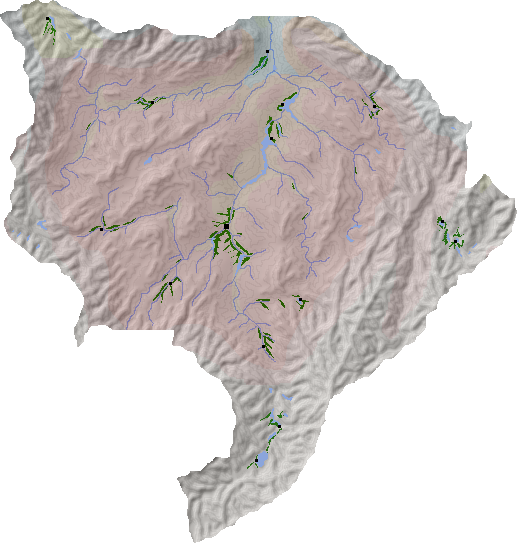
Two features dominate this Land: its height above sea level and its relative lack of rain. The average height of the Gromane plateau is around 720m, with the lowest point in the Rasluu Samen being 473m above current sea levels. The mountain ranges surrounding the Land, and its position in the centre of the continent in the dry belt region, limits the average annual rainfall to less than 170mm - making Gromane the driest Land on the continent.
Despite its height, the Gromane plateau is remarkably level, with a gentle average slope downhill from south to north. The river valleys that cut through the plateau are lower, and the rain that does fall in this region quickly gathers in these valleys in a series of long lakes. Key rivers include the Ripunuu and Ripulinuu, the Abrhuu, the Aframuu and the Estolhuu.
Some of the mountains that surround the Land are spectacular, with the northern and southern mountains being higher than those to the east and west. Key mountains peaks include (moving clockwise from Rasluu Samen): Rinduu (5,450m); Tilhahsuu (5,110m); Sumuu (4,580m); Frhituu (4,920m); Nishuu (5,860m); Kanduu (6,140m); Avakhuu (6,040m); Geltuu (6,220m); Pegasnise (6,340m); Estolhuu (4,700m); Aframe (6,970m); Gana'huu (3,780m); Baarhduu (5,250m); Ripluu (4,610m); and Samuu (4,080m).
Habitats
Gromane plays host to two unique habitats: the high desert and the high desert valleys. Surrounding these two habitats is a ring of dry foothills habitat, beyond which can be found a northern foothills habitat in the far north west and a north central mountains habitat in the east and south east.
Plantations and settlements
Uuwe Plantation sits at the centre of the Land, in the Nausuu Gromuun at the point where the Aframuu and Estolhuu rivers merge. In addition, there are 14 permanent settlements widely scattered across the plateau and foothills, ten of which are mining communities.
Gromane settlements are noted for having smaller populations than average, but come with the bonus of not requiring as much maintenance as an average cultivation once they have been established.
The two settlements at the base of Zeesuu Sumuu in the far east of the Land are both over 1,000m above sea level; the two settlements in the far south around Cebrhuu Kandon are both over 1,500m above sea level - with the southernmost set at an altitude of 1,880m
Key towns and cities
Rural population: 0 (0.0% of total)