Rhindose
Societal ties: Ambostak
Current population: 1
Main language(s): Ramajal
Area: 319,000km²
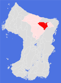
Natural and political borders
The northern border of the Land is formed by the Zoiznajarhuu Fesunizhuu, and extends southwards to the Soufwhuush Rindizhuush ranges. The Vosuu-Anguu-Stokuu ranges form a major watershed on the eastern borders of the Land.
The Land includes the river Ramuu east of longitude 177.1°E to where it divides into the Kiyuu and Cageluu rivers, and continues eastwards along the Cageluu to longitude 175.1°W. The whole of the Kiluu river system falls within its borders.
History
The explorers Behrl Groman mapped the courses of the Cageluu and Kiluu rivers as part of his third expedition in gt680-82; by gt740 the six original settlements had been established in Froshmuu Cagelen and Froshmuu Kilraelen. Even though most of the settlements were small, they each enjoyed an autonomous relationship with the Ramane authorities.
Settlers to the area had a frontier mentality as cultivation was difficult - even with assistance from the Ambostak army. The main attraction to the settlers was the prospect of mineral wealth, which helped foster a climate of individual entrepreneurship and a skeptical approach to laws made by people in a far distant city. Both valleys proved to be rich in an assortment of minerals; the first city in the region - Nezhaete - was founded on seams of silver in the valleys south of the plantation.
In gt792, army geologists discovered diamond deposits in the Froshmuush Angon; from the outset the army attempted to control access to the area. News of the discovery could not be kept quiet and by the next orbit thousands of people were trekking to the valley in the hope of making their fortune. Organised mining camps were broken up by the army, leading to fights between the prospectors and the authorities. Before the end of the orbit, citizens from settlements across the region had formed their own militias, who took to the field in the spring of gt794. Composed mostly of army veterans, the militias posed a serious threat to the Ambostak army, and had the advantage of shorter supply lines and the support of the valley settlements.
This crisis triggered the collapse of the old Ramane State in gt796 - largely without bloodshed. The Treaty of Kestrhuuwe, signed in gt799, saw all the territory of the Ramuu, Kiluu and Cageluu valleys east of longitude 177.1°E (including the Angon valleys) become a single independent Land - at the time the largest of the new Ambostak Lands.
Expansion continued after the crisis, though the cost of such operations meant that colonisation further east and south was slower than in previous centuries. The first settlements in the Froshmuush Tushon and Froshmuush Veriron, mainly by pioneers from the city of Cagelone, became viable in the late gt880s.
History seemed to repeat itself in gt932, when gem quality diamonds were discovered in the mountains around Tuuse Plantation. This crisis was bitter, bloodier, but shorter: unable to gather support from other Lands to suppress the revolt the Rhindose government agreed to its own dissolution and splitting the region into eastern (Rhindose) and western (Verirame) halves, with Tushe plantation becoming a free city.
Whatever the Rhindose cities lost as a result of partition was amply restored with the discovery of significant deposits of gold deep underground in the northern end of Froshmuu Angon in gt972. Unwilling to risk another political crisis, the government chose instead to declare all the wealth of the valley a 'common good' and took harsh action against unauthorised prospecting. Over the following century the wealth of the valley was systematically extracted; four new settlements were established specifically as mining towns with no permanent settlement permitted - given the harsh conditions in the valleys, few complained. Only in gt1117, when most of the economically productive gold seams had been worked out, were these conditions relaxed and permanent settlement permitted.
Politics and economy
The modern Land of Rhindose has operated since its establishment as a nation state based on democratic principles. Representation in the national parliament is based on geographical areas, and the representatives double up as local leaders. Politics is largely factional, and the past two and a half centuries have seen a fair share of charismatic leaders elected to office. One of the key benefits of gaining office was gaining access to the Angon goldmines and a number of dynastic fortunes have been built on the back of dirty politics and corrupt practices. This has been less of a problem since the populist revolts of the early twelfth century led to some political reform.
Mineral wealth dominates the national economy, and a wide range of service industries have developed to service those families who benefitted most from the Angon gold, particularly in the cities. Even so, agriculture is a key sector and the native population has worked hard to develop substantial and productive cultivations - though the Land remains a net importer of food and livestock.
One of the main cash crops grown in the Land is barley, from which some excellent spirits are brewed and distilled.
Culture and other issues of interest
The three cities of Rhindose are naturally competitive: much of the sporting and artistic activity across the Land consists of each city trying to out-compete the others. The main benefit of this activity has been the development of some beautiful city centres, each with museums, art galleries and theatres of note.
The monied classes make a point of supporting large-scale artistic endeavour - some of the best ensemble orchestras are found here, each offering regular seasons of music. Musical theatre is also very popular; the glamourous presentations in the best theatres find their echoes in theatres and vaudeville venues across the cities and settlements.
Favoured sports tend towards the confrontational - wrestling and various forms of boxing are staple part of everyday entertainment, though the best performers are often people from other Lands looking to make their fortune.
Despite the hard-playing and hard-drinking stereotype, most Rhindose folk take their religion seriously. Temples have no political role in the Land, and are officially barred from offering various social services; nevertheless, the role of the temple in local community life is important and threats of retribution have not stopped temple activism in the poorer communities.
Key natural features
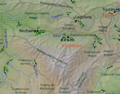
The Kiluu and Cageluu valleys form the heartlands of Rhindose: both are dominated by the mass of Zeesuu Kilraeluu, the 4,800m volcano that sits in the centre of the Land. The volcano has not erupted for thousands of orbits, though it remains the source of many of the earthquakes that regularly shake the area; it is the westernmost, and third highest, of the cluster of volcanoes that cover the northeastern corner of the continent - including Mts. Vosuu (3,910m) and Anguu (4,360m) on the eastern border.
The northern and southern ranges bordering Rhindose are taller than these volcanoes - Mt. Fesunu reaches 4,850m, while Mts. Rinduu (5,450m) and Tilhahsuu (5,110m) are higher still. The Rhindizhuush and Stokuu ranges are an interesting series of mountains themselves, short yet precipitous mountains running in a north-south direction. The Froshmuush Angon is the largest series of valleys cutting south into the mountains, and the source of much of the wealth of the Land.
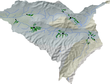
Habitats
The city of Nezhaete sits at the eastern tip of the northern valleys habitat associated with the Ramuu river. The rest of the Land occupies a northern scrublands habitat while Mts. Kilraeluu and Vosuu, and the Angon valleys, are part of the northern foothills habitat.
Plantations and settlements
Cultivation conditions are not ideal in the valleys, and only six settlements were established during the Ramane expansion. Three of these proved more productive than the others, consequently receiving most attention. In the northern Froshmuu Cagelen, the easternmost plantation grew most rapidly, eventually becoming Cagelone Plantation. The Froshmuu Kilraelen supports two plantations: Nezhaete in the west and Kilraele itself in the east.
The four settlements at the northern end of Froshmuu Angon are later developments, their cultivations are barely sustainable and most food is imported - the major activity of these settlements is the mining of gold.
Key towns and cities
Rural population: 0 (0.0% of total)