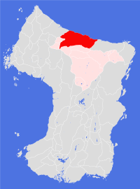
Ramane
Societal ties: Ambostak
Current population: 1
Main language(s): Ramajal
Area: 523,000km²
Natural and political borders
Ramane is a large coastal Land bounded to the west by Soufwhuu Varosuu and to the south by the Zoiznasuuftuu Fesunizhuu.
The Land controls all the river systems emptying along the Smikuu Raman and Dhounaelhuu Ramon between longitudes 170.7°E and 178.9°W, excluding the Albinuu river west of longitude 169.3°E and the Ramuu river south of latitude 38.9°N.
History
In gt526 the Hambosga army was ordered to start work on relocating settlements from Cheidrah to Ewlah. The army spent four orbits exploring and surveying the northern coastlands of Ewlah before deciding to concentrate their cultivation efforts around the Dhounaelhuu Ramon. The name they chose for the area - Ramane - came from the oldest Cheidran mythologies: the Golden city where civilisation first took root, where people learned the rules of democracy and the importance of laws.
It was not until gt541 that the first plantation - Strali - was able to receive significant numbers of immigrants. Subsequent cultivations upriver proved to be much easier to establish, with Ramane Plantation coming online in gt548. Jakove Plantation, west along the coast from Strali, opened in gt552.
After the initial settlement of Ramane the (newly self-named) Ambostak people entered a phase of consolidation, expanding their existing cultivations rather than establishing new settlements. Technological and scientific endeavour did not suffer greatly from the loss of contact with the Chiedran motherlands, though much effort had to be put into discovering and adapting new resources to existing knowledge; the greatest advances of this time were made in the field of agriculture.
Distance was one of the major issues for the Ramane State. Hambosga had operated as a single political and social entity, but worked less well for the more widespread settlements. In gt607 the State was divided into regions with limited local determination, a practice that continued during the State's expansion through the mid seventh century. The development of a railway network between many of the settlements and cities, built in the last quarter of the seventh century, helped to overcome some of these problems, but also led to resentment as a creeping centralisation set in during the first half of the eighth century.
The second half of the eighth century was a time of innovation and development across Ambostak Society. In gt792, army geologists discovered diamond deposits in the Froshmuush Angon; from the outset the State authorities attempted to control access to the area. Resentment of the army's actions in the southern regions soon led to the formation of local militias and the threat of civil war.
The collapse of the old Ramane State, in gt796, was both rapid and bloodless. As tensions continued to mount and with no apparent resolution forthcoming, Verhe Plantation in the west declared its independence from the State in the early spring. Within weeks Kraaje and Fenstrhuuwine Plantations had followed suit. Then on midsummer day, gt796, the temple hierarchy moved its headquarters from the city of Ramaje to Kestrhuuwe settlement, south of the Zoiznasuuftuu Fesunizhuu. The impact of this symbolic act was enough to cripple the State authorities and the army, allowing temple-mediated negotiations to start.
The result of those negotiations, the gt799 Treaty of Kestrhuuwe, saw the five Ambostak Homeland regions become the Land of Ramane - technically a new political entity, but culturally and socially the rump of the old Ramane State. The people of the new Land felt that they had in some way been betrayed by the other Ambostak Lands, a perception that coloured the Land's political and economic relationships with the other Lands for more than half a century. An unexpected benefit of this attitude was the strengthening of ties with the Bartak and Istran Societies to the east and west, and a new willingness to explore ancient technologies (such as electronic communications) which had previously been considered to be perilous knowledge and dangerous endeavours.
Politics and economy
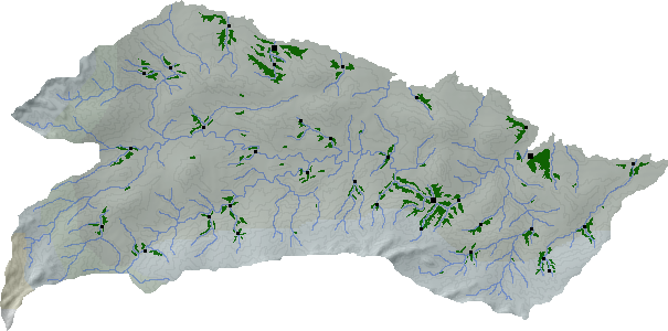
The four centuries following the establishment of the Land of Ramane have been largely peaceful and productive. Cultivations have grown at a slow yet steady rate, with the result that most settlements now have large areas of strategically abandoned woodland - the Land is a net exporter of Type Two timber products. It is also largely self-sufficient in staple food crops, and has developed large areas of pasture land (particularly in the coastal settlements) where horses and cattle are raised. For most settlements agriculture is the main economic sector, though each settlement has its own range of local light industries; a number of settlements across the Land are also important mining areas with iron, copper, tin, lead and asbestos being the main products. Deep coal seams have recently been discovered in the south eastern valleys and mines in these areas are currently being developed - most of the Land's energy to date has been generated from wind, solar and tidal power, alongside waste incineration and the burning of Type One false-plant biomass.
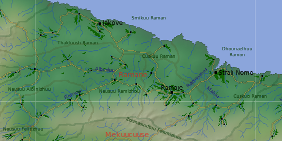
The city of Ramaje hosts a wide range of both heavy and light industry, and is one of the key regional centres for service industries including banking and other financial services - the Ramane Mark is legal tender in all Ambostak Lands and is widely accepted in a number of other Lands - most importantly Froutige, where it remains the national currency. Strali-Nome, in the east, hosts a range of heavy industries and rivals Ramaje as a manufacturing base. The city of Jakove has more light industry, and is also a key trading and transportation hub between the Ambostak and Bartak Society lands.
Since the mid tenth century much of the economic activity across the Land (and beyond) has been conducted through trading companies. There is a distinct divide between the public and private sectors and much of the politics of the past century has centred on the size and purpose of the public sector.
With almost fourty per cent the population residing in the largest city, the Ramaje region plays a leading role in the national political arena. Constitutionally, the Land is a federal democracy, with each of the five regions having considerable autonomy from the federal authorities; in practice the regions do as directed by the centre. The federal authority controls the Land's finances, and is closely involved in most policy areas. Each city and settlement controls their own housing and local social services (land is owned communally).
Culture and other issues of interest
People from other Ambostak Lands tend to characterise the typical Ramane native as arrogant, pushy, self-centred, money obsessed and culturally challenged. The Ramane folk do have a tendency to elect leaders with exactly these qualities, which only helps to reinforce the stereotype.
Most Ramane natives are not as extreme. In areas outside Ramaje, people tend to be welcoming, fairly pious, and family orientated, and have a strong pride in their locality. Religion is a community affair and the local temple will often serve as the local community centre. Ramaje itself is a far more cosmopolitan affair, where individual concerns tend to overshadow more traditional allegiances to the family and temple. Population movements are far greater within Ramaje than between Ramaje and the rest of the Land.
While artistic endeavours are encouraged, Ramane has produced few artists of great renown. Competitive sports play a greater role in the lives of the average Ramane and the Land hosts a range of professional and semi-professional sporting organisations. By far the most popular spectator sport is horse racing - many people mark their calenders according to key races throughout the orbit rather than the key religious festivals. Most horses are owned nowadays by rich individuals or companies, though a number of settlements still maintain a string of horses - a successful racer can generate significant income (from prize money) for the settlement that owns it.
Key natural features
Most of Ramane is low-lying (less than 600m above current sea levels), with ranges of hills such as the Thakluush Raman separating broad valleys, most notably the Albeduu, Ramuu and Maluu river valleys. The Ramuu river, which reaches the sea near to Strali Plantation, is the second largest river system on the continent.
Habitats
Almost all of the settlements and plantations in Ramane fall within the north coastal habitat, with the southernmost settlements along the Zoiznasuuftuu Fesunizhuu experiencing a northern scrublands habitat.
Plantations and settlements
The old Ramane State was divided into regions, most of which became independent Lands in gt799. The Land of Ramane is composed of the five oldest regions, known collectively as the Ambostak Homelands: the northern coastlands of Jakove region; Male region in the east; Ramaje region, covering the lower reaches of the Ramuu river; Albede region in the west; and Nasrame region in the south west.
Ramaje Plantation is the largest plantation in the Land, stretching over 200km along the Ramuu and Ramousuu rivers, and the most heavily populated - the city of Ramaje accounts for almost forty per cent of the total population. Three other settlements also form part of the plantation, which is continuing to expand towards the two westernmost settlements in the region; the two westernmost settlements in the Maluu river valleys also form part of Ramaje region.
To the east of the Ramousuu estuary sits Strali Plantation - the oldest plantation in the Ambostak Lands. The city of Strali-Nome is the capital of Male region, which includes six other settlements across the eastern parts of Cuskuu Raman.
The third city in Ramane - Jakove - sits in its own extensive plantation on the northern coast, rivaling Ramaje Plantation in its extent, but not in its population. Six other settlements stretched along the Smikuu Raman and in the Thakluush Raman make up the rest of this region.
Albede is a region composed of six smaller settlements strung along the Albeduu valley - it is the least populated of the Ramane regions. Nasrame region lies to the south of Albede, and includes five settlements in the Ramuu valley; three along the river itself and two in the upper reaches of tributaries.
Key towns and cities
Rural population: 0 (0.0% of total)