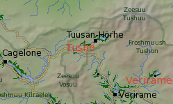
Tushe
Societal ties: Ambostak
Current population: 1
Main language(s): Ramajal
Area: 18,000km²
Natural and political borders
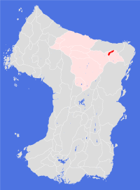
The borders of Tushe are entirely political, and for the most part physically marked - the only Land to be so defined. The eastern and western borders are set on the Cageluu River at longitudes 175.1°W and 174.5°W - a distance of about 55km. These borders extend north-south until they meet the local watersheds of the tributaries that flow into the river between those marks and extend north-eastwards to the peak of Mt Tushuu and south-westwards to the peak of Mt Vosuu.
History
The first settlements in the Froshmuush Tushon, mainly by pioneers from the Rhindose city of Cagelone, became viable in the late gt880s. Of the four settlements in the valley, only one survives to this day
The first five decades were uneventful. Then in gt932 gem quality diamonds were discovered in the mountains around Tuuse Plantation - a discovery which triggered a bitter and bloody conflict between the western and eastern parts of the (then much larger) Land of Rhindose.
A resolution of the conflict was mediated by the Ambostak Temple, the result of which was the division of the old Land into three new political entities: Rhindose in the west; Verirame in the east; and the Free City of Tuusan-Horhe between the two. The agreement established the ground rules for a power-sharing political solution within the Free City, and providing equal access to the mineral wealth of the valley.
The agreement finally failed in gt951, when local settlers and miners joined together to expel the corrupt parties from the neighbouring Lands from the city. In gt952 the new regime declared itself to be a sovereign Land equal in stature to its neighbours, leading to the first of many economic blockades. The western border of the Land with Rhindose was not agreed until gt1018 and the eastern border was finally settled with Verirame in gt1070.
Politics and economy
Politics, blockades and other forms of interference all contributed to the slow development of the deeper diamond mines, which is one reason why they remain active to this day. The diamonds are found in a series of lamproite pipes which are the product of a number of ancient volcanoes that have formed in the area - the much more recent outflow of Zeesuu Tuushuu has covered these more ancient deposits, making their extraction more difficult. The mines also produce commercial quantities of titanium, chromium and nickel.
The Land has, over the two and a half centuries of its existence, become a byword for corruption, nepotism and brutal political intrigue. During this time it has been invaded four times: in gt990 and gt1105 by Rhindose; and in gt1068 and gt1131 by Verirame. On each occassion, the occupation lasted no more than two years as the two larger Lands took action against each other to force a withdrawl. Tensions remain high in the area, and the local settlers have become adept at playing off each side for their own gain.
The political environment is nominally democratic: however, there are three well-established power blocks within the city who routinely attempt to fix elections for the advancement of their own economic needs.
Both the river and the land trade routes that pass through Tushe territory are regularly patrolled by Verirame and Rhindose armed forces: the routes are a significant trade bottleneck between the wider Ambostak Lands and the Land of Froutige to the south.
Culture and other issues of interest
There is little cultural activity of note in the valley or the city. The city itself is a mix of extravagant displays of wealth alongside neighbourhoods stricken by high levels of poverty and low levels of public services. The one thing that unites the people who make the valley their home is the dream of wealth - the river valley is rich in alluvial deposits of both diamond and metals.
The main export of the Land is said to be "criminals" - Tushe natives enjoy a poor reputation among their neighbours, and indeed further afield. Whatever the truth of this stereotype, it remains a fact that many locals are happy to play up to it when they believe it to be in their interests.
Key natural features
The Tuusuu river flows towards Mt Tushe. Lake Horhuu is found midway along the river's course. Both of these features have been extensively affected by mining activity - and some scientists have argued that the lake is not a natural feature, but rather an ancient artificial construction that may have stood for over three thousand orbits. The frequency of earthquakes in the area would make this an astonishing feat of engineering if it were proved true.
Habitats
While the Cageluu valley at this elevation enjoys a northern scrublands habitat, most of the course of the Tuusuu river (and thus most of the cultivations in the Land) lies within a northern foothills habitat.
Plantations and settlements
The only cultivation in the Land is the Horhuu Plantation which surrounds all sides of the lake and extends southwestwards down the Tuusuu valley. Plans for establishing settlements along the Cageluu valley or south of that river have yet to be realised.
Key towns and cities
Rural population: 0 (0.0% of total)